Cultural Tourism
GWANGYANG
Cultural Tourism
9 Scenic Sites
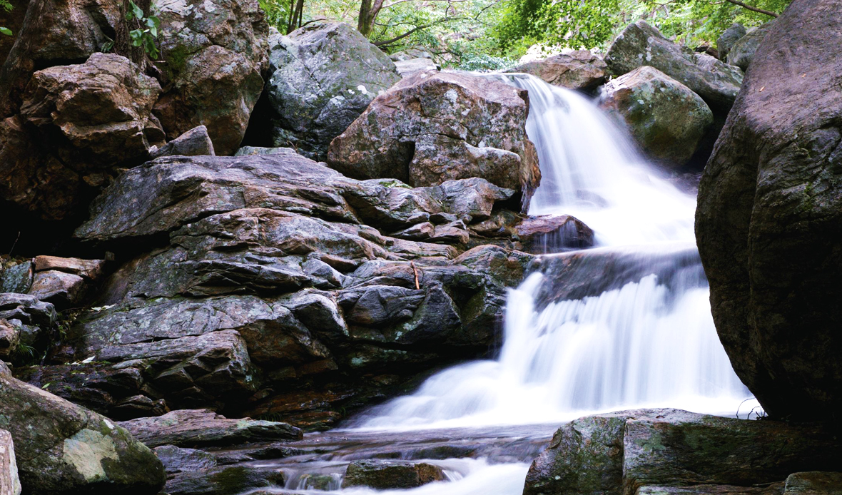
Baekunsan Mountain (1,222m) in Gwangyang is famous for its four clear and clean valleys that flow along the dense primeval forests that covers the skies. The main ridges leading from Sangbong Peak, the summit of Baegunsan Mountain, to Maebong Peak to the east, Taribong Peak, Dosolbong Peak, and Hyeongjebong Peak to the west, and four major valleys
which come down from the 10km main ridge, Seongbul, Donggok, Eoch, and Geumcheon Valley, respectively, boast beautiful scenery.
Baegunsan Mountain is the highest mountain in Jeollanam Province. The mountain is deep, and the valley is deep, the water is clear like glass, and it is cold enough to make your hands shiver.
Baegunsan Mountain has the clearest water, strange rocks, strange rocks, large and small waterfalls, and Donggok Valley in Okryong-myeon, including Eoch Valley in Jinsang-myeon, the shortest of the four valleys, Seongbul Valley in Bonggang-myeon, Haksadae, Yongso, and Seonyudae, and there are Geumcheon Valley and these four major valleys in Daap-myeon, which are rich in water, so anyone can set up a tent and fall into conversation, healing the mind and body of everyone who is tired of daily life.
- Seongbul Valley : Gwangyang IC → Gwangyang-eup → Bonggang-myeon → Joryeong-ri (14.5km)
- Donggok Valley : Gwangyang IC → Gwangyang-eup → Oknyong-myeon → Donggok-ri (12.3km)
- Eochi Valley : Okgok IC → Jinsang-myeon → Sueo Dam → Eochi-ri (14.1km)
- Geumcheon Valley : Okgok IC → Daap-myeon → Geumcheon-ri (30km)
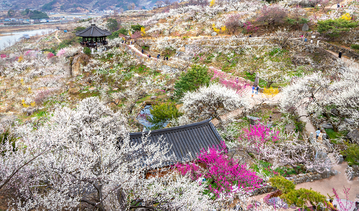
Every March, the edge of Baegunsan Mountain in the lower stream of the Seomjingang River is dazzling with white plum blossoms, and the plum blossoms hanging on the Seomjingang River urge spring and convey the spirit of a scholar. The
spirit of a master who has been cultivating plum blossoms for three generations has been passed down with more than 2,500 traditional pottery, and recently, wildflowers such as big blue lilyturf and Siberian chrysanthemum every season and
are in the spotlight as tourist destinations for all seasons.
In the season when winter ice melts and haze tickles the armpits of soil, the famous plum village in Gwangyang is a good place to take a camera.
Gwangyang Plum Blossom Festival is one of the biggest festivals as it has become famous to foreigners and expanded to an international plum festival, and it is held at the earliest time in the country as a flower festival under the theme of plum blossoms.
Passing through the green barley field on the road behind the plum farm, you can see the spectacular plum blossoms with exclamations.
The beautiful appearance of plum blossoms that overcome the cold winter such as red plum blossoms and green plum
blossoms and color the world brightly can only be seen in Gwangyang.
- Location : Jimak 1-gil, Daap-myeon, Gwangyang
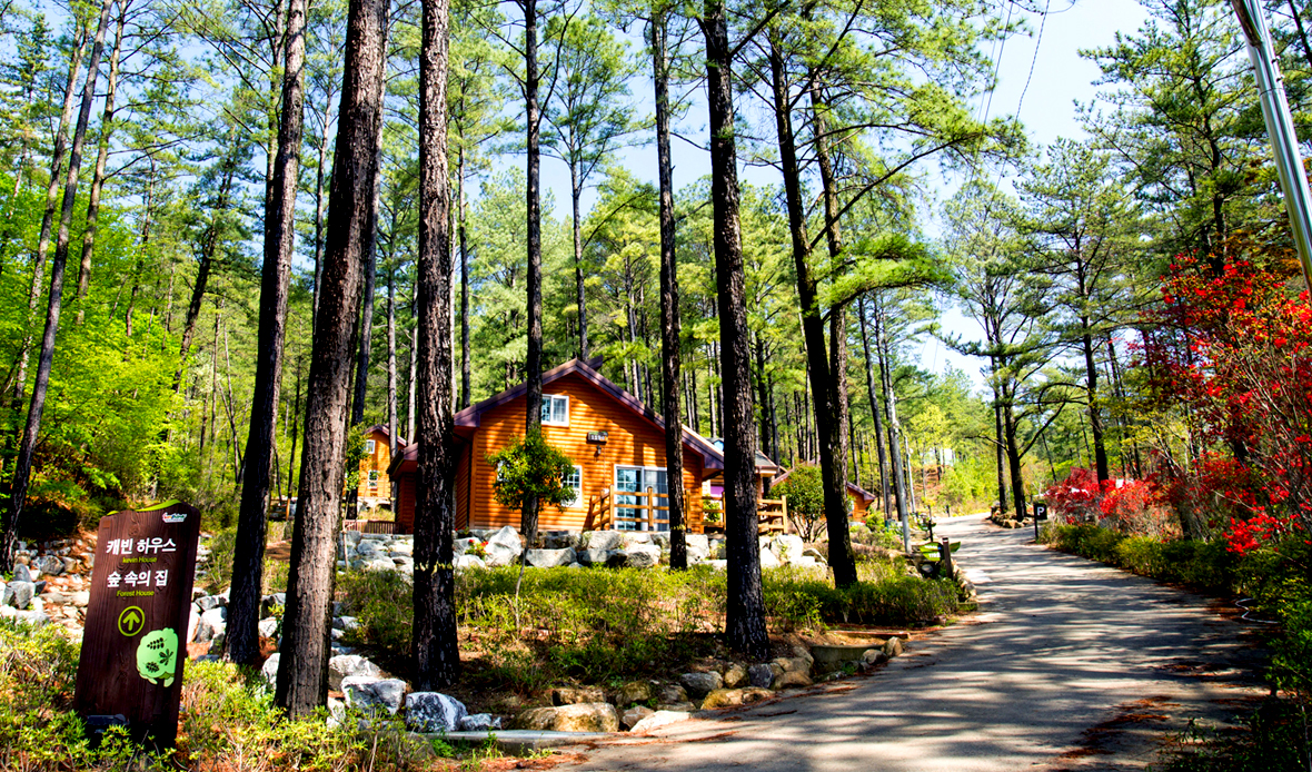
Beautiful trees, such as well preserved primeval forests, cedar trees, and cypress forests, spread out like carpets, draw
admiration from viewers. Convenience facilities such as mountain hut, red clay room, general accommodation building, forest bath, wildflower complex, auto camping site,
red clay road, and forest shelter are well equipped between the forests.
Is there a better place to heal stress than here? It is not just a forest, but a place where you can meet a well-organized and elegant forest, and it is Baegunsan Mountain Natural Recreation Forest, where people who come here once visit it more than two or three times.
If you go to the Healing Forest Center, you can see facilities for healing such as a health measurement room, yoga
meditation room, phytoncide book cafe, footbath, aroma therapy room, and sunbath terrace.
You can also stay at Baegunsan Mountain Natural Recreation Forest, where 1~2 campsites, caravans, car camping sites, and forest houses and cabin houses, which are indoor accommodations, are in operation.
In addition, there is also a wood experience center where people from infants to adults can touch and feel wood themselves and make woodwork.
- Location : 337, Baekgye-ro, Oknyong-myeon, Gwangyang
- Contact : 061-797-2655 (Baegunsan Natural Recreational Forest)
- Website : bwmt.gwangyang.go.kr
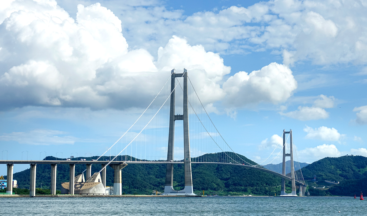
The Yi Sunshin Bridge, which connects Gwangyang and Yeosu, is the longest suspension bridge in Korea and the world's seventh largest, making it worth seeing.
The night view of Gwangyang Port and the appearance of Yi Sunsin Bridge from Myodo Island, Yeosu City, complete a
work that is difficult for any painter to paint.
The total length of 2,260m is 1,545m between the bridge tower and the bridge tower. Here, 1545 refers to the year 1545
when Admiral Yi Sunshin was born.
The 270m height of the tower is higher than the 63 Building in Yeouido as well as Namsan Mountain in Seoul, and it is the world's best concrete bridge tower.
You can feel the beauty of driving with your lover and family, so you don't have to envy the Golden Gate Bridge in San
Francisco.
- Embracing Literary Remains of the Poet Yun Dong-ju
The Seomjingang River, which originated in Jinan, Jeollabuk Province, is the lifeline of Jeolla Province and Gyeongsang
Province. The water quality is the clearest among the five major rivers in Korea, so swarms of sweetfish, the epitome of
clean fish, and corbiculas and small eels live in large quantities. Seomjingang River was called Dasagang River due to its
large amount of sand, and it was named Seomjingang River because of the legend of a toad that prevented the invasion
of Japanese invaders in the late Goryeo Dynasty. At the end of it, Mangdeok Port, which embraced Poet Yun Dongju's
legacy, is located.
If you come down south along the winding Seomjingang River waterway, you will find Mangdeok Port, a complex of Seomjingang River restaurants.
Mangdeok Port is the starting point and end point of the land section of the Seomjingang River Bicycle Road, which novelist Kim Hoon praised to the greatest possible extent.
Cherry oysters, which must be tasted in Mangdeok Port, are named because they are said to be the thickest and most delicious when cherry blossoms bloom,
but they are more precious and popular because they are not farmed.
In addition to food, Mangdeok Port has the Seomjingang River Jongju Bicycle Road, which is loved by Korean bicycle riders.
Among them, the fifth course, which is the Gwangyang section, is 37.7km long from Namdo Bridge to Maehwa Village to
Baealdo Waterfront Park, and is a course where you can see the Seomjingang River properly.
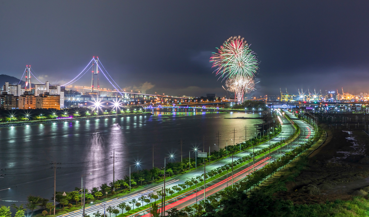
Gwangyang Bay is an inland sea between Gwangyang City and Yeosu City, and is connected to the South Sea to the east, with Myodo Island in the center and islands such as Songdo and Jangdo Island in the west. Here in Gwangyang Bay,
POSCO Gwangyang Steel Mill, Yi Sunshin Bridge, Gwangyang Port, and Yeosu National Industrial Complex are located, and beautiful lights unfold in a panorama at night, giving hope and emotion. Gubongsan Mountain Observatory is the night viewpoint.
Except for the night view of Gwangyang Bay, do not mention the night view of the port. In Gwangyang Bay, there are islands such as Myodo Island, Songdo Island, and Jangdo Island, and wide tidal flats are formed along the coast.
Gwangyang Bay, where large ships also freely come and go, is enough to impress everyone with the impression of dawn and the afterglow of sunset.
Gwangyang Bay is the western end of Hallyeohaesang National Marine Park, and not only is the natural scenery of the coast beautiful, but it is also in the spotlight as a tourist destination because there are many historical sites of the Japanese Invasion of Korea in 1592, including Battle of Noryang.
Gwangyang Bay is safe for ships to anchor due to the calm waves as the Yeosu and Namhae Peninsula functions as a natural breakwater, and is convenient for large ships to travel due to its deep water depth.
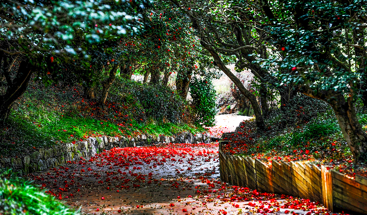
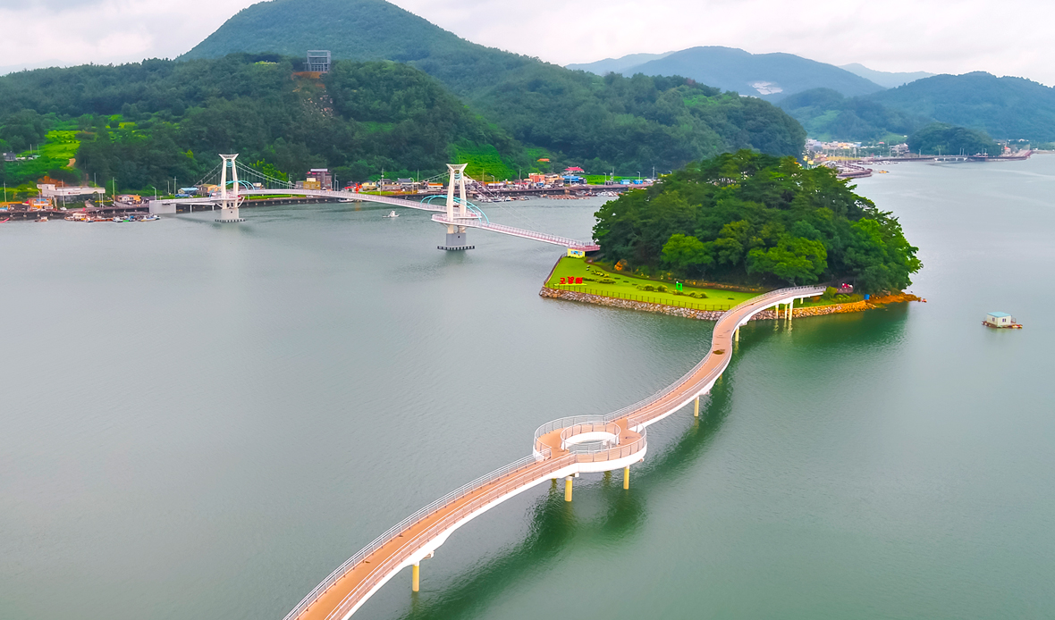
It is a place where hundreds of disciples were trained for 35 years until High Priest Preceptor Doseon of Silla, entered a reconstructed temple.
More than 10,000 camellia trees planted to reinforce the energy of the land at the time of reconstruction form a forest and were designated as Natural Monument No. 489.
It is said that the Seongakguksa Doseon, a monk at the end of the Unified Silla Dynasty and known as the master of geomancy, planted camellia trees to reinforce the energy of Okryongsa Temple in the south of Baekgyesan Mountain (505m), the branch of Baegunsan Mountain.
The camellia tree here has a thousand years of history, retaining its greenness throughout the year. Currently, more than 10,000 camellia trees that are more than 100 years old form a community complex around the temple site.
It has been designated as a natural monument (No. 489) because it retains the original form of the temple forest in the southern region. Preceptor Doseon raised many disciples during his 35 years at Okryongsa Temple from 864, and he passed away here.
Okryongsa Temple disappeared into history with only traces, but the largest camellia forest in Korea blooms red camellia flowers from February to April every year.
- Location : 71, Baekgye 1-gil, Oknyong-myeon, Gwangyang
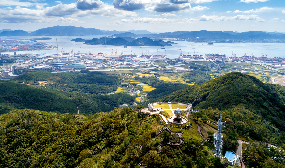
As an observatory installed on Gubongsan Mountain at 473m above sea level, you can see Suncheon, Yeosu, Hadong, and Namhae at a glance,
and there is a 9.4m Beacon Fire Station at the top, making it a new sunrise spot.
It is also a tourist attraction where you can see the wonderful night view of Gwangyang Bay.
Considering its historicity, Beacon Fire Station was built at 940m in height, meaning 940m (23rd year of King Taejo of Goryeo), when the name Gwangyang was first named in Huiyang.
In particular, Beacon Fire Station is the world's only iron art digital, and it contains the image of a beacon symbolizing the vitality of flowers blooming into plum blossoms by utilizing light, iron, flowers, and ports symbolizing Gwangyang.
In addition, petals represent the twelve terrestrial branches and twelve eup, myeon, and dong, and use special steel and LED lighting to match Gwangyang's image as a city of light and iron to maximize regional characteristics.
- Location : 369-155 (Seonghwang-dong), Yongjang-gil, Gwangyang
- Contact : 061-791-7627 (Facility Management Division, Gwangyang)
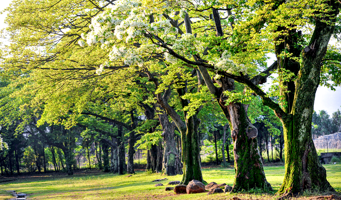
Gwangyang Forest is a cultural resource that makes it possible to see the military purpose of our ancestors and the wisdom of preventing the sea wind,
and the Retusa fringe tree is a very large and old tree and has been designated as Natural Monument No. 235 along with Gwangyang Forest because of its biological preservation value.
After Park Sehoo, a prefectural governor of Gwangyang, built Gwangyang Eupseong Fortress in 1528, he planted nettle trees and Retusa fringe trees so that Japanese invaders could not see them from the sea.
In addition, according to the theory of geomancy, a pond was dug and weeping willows were planted to compensate for the empty parts of the village.
It's a complementing forest that cheers up the village. Over the years, the castle disappeared, but the trees became forests. It is the site of Yudang Park.
At first, the village forest was a military security forest that prevented the castle from being seen, but gradually it also served as a windbreak forest to prevent wind damage.
Among them, the 18m-high and 3.4m-chest tree was designated as a natural monument in 1971 in recognition of its biological preservation value and cultural value since we can see the wisdom of our ancestors in the tree.
The name of the cultural property was later changed to ‘Gwangyang Forest and Retusa fringe tree’ along with other trees.
Retusa fringe tree was called Ipha Tree or Rice Tree because it was said that white flowers bloom like white rice sprinkled on green buds around the initial day of summer(Ipha).
With the appearance of blooming, they guessed the good and bad harvests of rice farming that year, and they thought that if a lot of flowers bloom, it would be a good harvest, and if they bloomed scantily, it would be a bad harvest.
This is because the Retusa fringe tree grows well in places with a lot of water.
- Location : 14 Baegun-ro, Gwangyang-eup, Gwangyang